BEN LAWERS GROUP
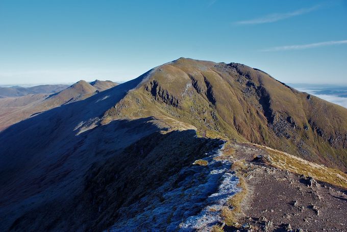
B Lawers from B Ghlas. The new Mnro An Stuc and Meall Garbh are the peaks to the left. Photo tms.nickbramhall.com
11.8 miles 1557 metres
Start Tuesday 21.38
Meall a' Choire Leith 22.10
Meall Corranaich 22.35
Beinn Ghlas 22.54
Ben Lawers 23.09
Meall Garbh Wednesday 00.01
Meall Greigh 00.40
Finish 01.11
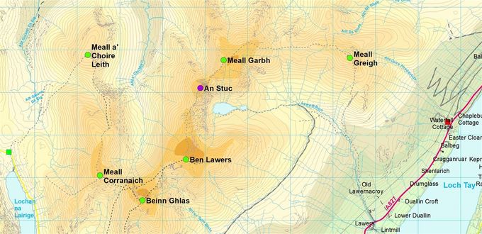
Squares: green - start, red - finish. Circles summits: green - this leg, blue - not a Munro in 1990. Map Colin Matheson
Time: Estimated 4.00 Actual 3.33
It was a beautiful evening as I set off over the intervening ridge. Somehow, even though starting high should be rewarding, it is not psychologically encouraging to have to run downhill on your way to the first hill. However it was quick and enjoyable going.
At the top of Meall a' Choire Leith I had possibly the best sunset I had ever seen. The whole sky glowed red lighting up vast tracts of the Highlands. On arrival I could see Ben Nevis, although it disappeared almost immediately. In fact a great mass of cloud in the west was advancing at a phenomonal rate. After a few minutes I set off determined to reach Ben Lawers before dark.
Approaching Meall Corranaich just 25 minutes later, a cool breeze sprung up, and suddenly it was no longer warm in sweat shirt and shorts. Still, both the next two Munros were short distances, and I was therefore going to push for quick times.
Beinn Ghlas may be near, but the drop is deep and steep. It was also sheltered, and nineteen minutes later, as I gained the main ridge, I was surprised how dark it had become and how much the weather had deteriorated. Ben Lawers had disappeared in the cloud, and a stiff south eaasterly blew across the ridge. Nevertheless I set off fast for Lawers. By the saddle I was no longer able to see well enough to run at full speed. By the time I reached the summit, the rain was lashing across in thick cloud, only fifteen minutes since Beinn Ghlas.
I was very cold, and set about donning all my clothing, a task that actually required me to strip off first. Because I was so cold it took a long time, far longer than the time saved through moving fast. I recorded it as 17 minutes, but retrospectively, I think I must have misread my watch in the dark.
Years ago, on a clear sunny summer day, I met a teenager on Beinn Ghlas who had come up the tourist path with enough gear for a week's outing. On seeing a small cumulus cloud obscure the sun, he had confided in me that he thought it would be safer to turn round, and I failed to persuade him that he would be perfectly safe on the path to Lawers. I had gained much mischievous amusement from this, as indeed I did on this trip by Ian's mighty packs. There was continuous banter between Ian and me about the amount we saw fit to carry. There is one thing of which I am certain – I am far safer now with years of experience than when in my younger days I also carried the kitchen sink.
Had I not used my compass, I would have set off down the eastern ridge towards Loch Tay. Generally the worn path was easy to follow, but every now and again it would disappear. I decided to risk contouring round An Stuc, a sizeable steep sided bump (since promoted to Munro status.) Steep grass took me round to the craggy northern side, where I found a well used path which took me easily between the cliffs.
I was soaked through although no longer cold, but I was longing for a warm shower in the camp site, so Meall Garbh seemed to go on for ever. The summit provided brief aesthetics as it was clear between layers of cloud, with the summit of Ben Lawers also visible. Back into the cloud, I dropped out of it again not far above the saddle.
Meall Greigh was interminable tussocky grass in my memory, so I was surprised to enjoy it. I found myself able to run much of it using a torch only to read the map, from which I picked up all the changes of slope on the way.
The descent of the unknown east side started fast over good going running with a torch. I hardly noticed the imperceptible steepening until suddenly I was out of control, desperately trying to keep my feet under me, as at least every other step landed on steep slippery rock. Mercifully there was enough vegetation to allow me to stop, as the next few hundred feet were liberally spattered with boulders. I was surprised at the volume of water in the streams on the lower slopes, and later on the road. It is amazing how concentration in the hills can leave you unaware of rain. Once I finished an orienteering race thinking how well I had timed it as the rain started, only to be told that it had been raining hard for an hour.
Peaks done 242 time taken 10 days 22 hours peaks to go 35
There is no charge for reading this account but please consider donating to Worldwide Cancer Research, the new name for the charity that we ran for.
Share this page

